
Welcome to the IPOC 2014 Mw 8.1 Pisagua Earthquake special event page!
This page will give you information about IPOC activities before and after the 2014 Mw 8.1 Pisagua Earthquake. This includes background information, actual news of our partners in the field, and first results. See the actual seismological information and results on the special event page of the GEOFON website of the GFZ Helmholtz Centre for Geosciences, Potsdam, Germany.
Content:
The 2014 Mw 8.1 Pisagua Earthquake
On 1st April, 23:46:50 UTC, an Mw 8.1 earthquake ruptured offshore northern Chile, near the town of Pisagua northwest of Iquique, followed two days later by a Mw 7.6 event, both in the centre of the Integrated Plate Boundary Observatory Chile (IPOC, see map).
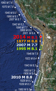
These earthquakes were expected. They occurred within a seismic gap left behind by two large earthquakes devastating the northern Chilean and southern Peruvian coast about 140 years ago in 1868 and 1877 (see map). This segment, about 500 km long, was the only one along the Chilean subduction zone that has not ruptured within the last century. The two neighbouring segments to the North and South broke in 2001 and 1995 in Mw 8.4 and Mw 8.1 earthquakes, respectively. The earthquake was recorded by 20 IPOC multi-parameter stations plus several additional off-line strong- and weak-motion instruments. A network of GPS monuments, covering the onshore region deformed by the earthquake, was measured just weeks before the event by GFZ scientists. The earthquake was heralded by several precursory earthquake swarms, including four earthquakes Mw>6 within the last months, which were all well recorded by our stations.
CROSSCHECK WITH NATURE PAPER Preliminary analysis indicates that the Pisagua earthquake broke the centre of the seismic gap along an about 100 km long piece of the megathrust fault, leaving large segments capable of producing at least two more M>8 earthquakes to the North and South unbroken. In fact, it appears that the earthquake and its fore- and aftershocks did not break the most strongly locked segment of the plate interface (Mětois et al, GJI 2013), but instead occurred within a local minimum of the along-strike locking pattern.
First results were published in August 2014 in Nature Geosciences (Schurr et al 2014)
Rapid Field Campaigns
[8 April 2014] After the M 8.1 and M 7.6 earthquakes from April 1st and 3rd 2014, several international research teams are preparing field trips to the affected regions in Northern Chile and IPOC to install new instruments, retrieve data from offline-instruments, re-measure GPS monuments, etc. The assignment aims at gaining a better and more detailed understanding of the rupture process and the rupture surface based on the aftershocks and their distribution, as well as subsequent surface deformation and a possible effect on triggering volcanic activity.
For the seismological part, a German team of the newly formed GFZ response team HART (Hazard and Risk Team) is currently preparing 30 portable seismometers for air transport (broadband seismometer and 3D-component geophones for shorter period recordings). 24 of them will be used to densify the existing seismic network of the IPOC observatory (Integrated Plate Boundary Observatory Chile) and to also incorporate the regions North and South of the current rupture to account for the increased risk of the neighbouring segments to break too. The German group of approximately eight scientists will travel to Chile within this week and will be joined by a Chilean team from the University of Chile in Santiago, where currently c. 30 additional seismometers are being prepared for the North. A French IPOC team is also planning a field trip to collect data of their IPOC stations. Geomar in Kiel, Germany, is currently investigating options to send Ocean Bottom Seismometers (OBS) for an offshore deployment which may be operating 5-6 months after their installation.
The international GPS community (mainly Chilean, US, France, German) is actually prparing teams to the field to visit all permanent cGPS sites maintained by or in collaboration with CSN (LIA, CALTECH, CSN), to make sure all cGPS sites are working properly. the field to visit all permanent cGPS sites maintained by or in collaboration with the Servicio Sismológico Nacional de Chile (LIA, CALTECH, CSN), to make sure all cGPS sites are working properly. Their first strike team is already in the region deploying instruments in a profile near the epicentral region (Pisagua and up to the cordillera). GFZ Potsdam is planning a timely repeat of the just-finished pre-seismic GPS campaign will allow to measure the co-seismic 000static displacement induced by the rupture putting valuable constraint on the slip distribution of the earthquake. Two continuous GPS stations as well as additional GPS monuments shall be implemented and measurements in the greater region are planned to be prepared for possible further great earthquakes contiguous to the Pisagua earthquake. A further remeasurement campaign later in the year would allow assessment of the postseismic response.
Within IPOC various parameters at two volcanoes in the volcanic arc close to the Pisagua earthquake are monitored. Goal of a rapid response field trip would be to collect data from offline stations (temperature, camera, and seismic data) at the volcanoes Lascar and Putane that may show activity at the volcanoes before and after the earthquake. It is planned to densify the seismic network at Lascar volcano (the remaining six seismic stations will be installed there). As more and large aftershocks are expected, a possible triggering effect at the volcanoes might be studied.
Members of the German HART Team are also planning to install two additional magnetotelluric (MT) stations, north of the existing network, to study long term effects of the deep hydraulic system in the aftermath of the Mw 8.1 earthquake. MT data are currently collected at nine IPOC sites, covering the southern part of the network.
Sea Level Changes
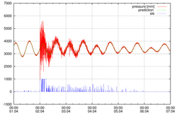
Tide gauges along the Chilean coast have continuously recorded sea level heights before and after the 2014 Mw 8.1 Pisagua Earthquake. The graphs show a record for Iquique (raw and de-tided) from 1-7 April 2014.
The green line in the left figure shows the modeled normal tide gauge, the red line is the measured data. The vertical axis indicates the sea level height measured with a radar gauge. The figure shows the arrival of the tsunami on April 1st at 23:58 h in the harbour of Iquique, i.e. 11 minutes after the earthquake, causing the water to rise for c. 1.8 m and sink for c. 2.5 m at a maximum. The subsequent tsunami waves are consequently weaker, but the normal tide gauge is not reached before April 4th around 12 pm.
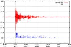
The figure to the right shows the de-tided sea surface height (ssh), i.e. the sea surface height anomaly induced by the tsunami. It is interesting to recognize, that the next-to-the-source tide gauge (Pisagua), was vertically displaced by ~30 to 35 cm (which is similar to the GPS values of Mitja Bartsch, GFZ Potsdam).
The blue line ( sle = sea level excess) is a calculated indicator for sea level anormalies. The detection algorithm (tgd = tide gauge daemon) was developed for the German Indonesian Tsunami Early Warning System (GITEWS) where it is used to alert the Warning Centre in Jakarta and to start near real-time data transmission as soon as possible. The algorithm also triggers the station into a high-rate reporting mode and provides the event time to the warning centre.
26 new seismic stations installed
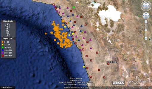
[10 April 2014] In coordination with the Seismological Center (CSN) and the Geophysics Department (DGF) of the University of Chile, a Chilean team led by Sergio Ruiz and Diana Comte (Departamento de Geofísica, Universidad de Chile, Santiago) are taking the lead on seismic station efforts in Chile.
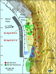
The map (copyright: Google Earth) shows the distribution of seismic stations in Northern Chile (approximately between Antofagsta and Arica) and their relation to the USGS Magintude 4.5+ Earthquakes between the 2-8 April 2014 (circles, size correlates with the earthquake magnitude).
One week before de Pisagua Mw=8.2 earthquake, 10 temporary broadband (BB) stations (blue triangles) were deployed around Pisagua-Iquique area. Immediately after the occurrence of the Pisagua earthquake, we deployed 16 additional BB stations (purple triangles), obtaining at the moment 46 BB stations, considering the 20 CSN and IPOC permanent stations (red squares). The Iquique Local Network project has 5 additional seismological stations (yellow triangles) operating in the area.
7 new broadband stations installed at volcanoes Lascar and Putana
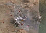
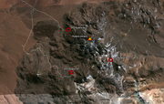
[11 April 2014] As one of the first groups of the German Hazard and Risk Team (HART, GFZ Potsdam), a German/ Chilean team of volcanologists and seismologists (see team members below) reached the region, collected temperature, camera, and seismic data from existing offline stations, and installed seven new seismic broadband stations at the flanks of the volcanoes Lascar and Putana close to the Chilean/ Bolivian/ Argentine border. The aim is to densify the survey of the volcanoes and to detect a possible triggering of volcanic activity after the 2014 Mw 8.1 Pisagua Earthquake.
The Google Earth snapshot on the upper right image shows the distribution of seismic stations around the Lascar volcanoe. Five new seismic broadband stations (GFZBB1-5, red symbols) were installed in the southeast and northwest of the volcano at altitudes between 4100 and 5100 m. The new stations densify the existing network of three broadband stations run by the Chilean Geological Survey (Sernageomin, yellow symbols) and one MARK-3D 3-component geophone for shorter-period recordings that has been installed in 2013 (GFZSP, red symbol).
The Putana Volcano (lower right) is now monitored by three seismic stations, one MARK-3D 3-component geophone that was installed in 2013 and two newly installed broadband stations (GFZ Putane BB1 and BB2).
Team Members:
- Thomas R. Walter (GFZ Potsdam, Section 2.1)
- Jackie Salzer (GFZ Potsdam, Section 2.1)
- Stefan Mikulla (GFZ Potsdam, Section 2.1)
- Christian Kujawa (GFZ Potsdam, Section 4.2)
- Ayleen Gaete (Sernageomin Chile)
Read more about the Volcanotectonics Group of GFZ Potsdam at https://www.volcanotectonics.de/
News from the Field: Seismology
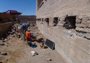
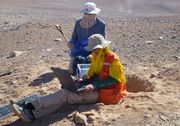
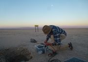
[17 April 2014] After successfully installing 14 seismic stations, the German/ Chilean team (G. Asch, P. Arias, A. Manzanares, and P. Salazar; GFZ Potsdam and U Católica del Norte) picked up the remaining 10 mobile stations in Antofagasta, and leave today to install them in the IPOC region.
This field campaign is part of the joint field initiative between the University of Santiago (Chile) and the German HART team from GFZ Potsdam and aims to densify the existing IPOC network in order to gain a better and more detailed understanding of the rupture process and the rupture surface based on the aftershocks of the 2014 Mw 8.1 Pisagua Earthquake and their distribution.
The 24 German seismic stations accomplish the 26 stations already installed by the Chilean teams led by Diana Comte and Sergion Ruíz during the past 4 weeks, i.e. after increased seismic activity following the Mw 6.7 earthquake form 16 March 2014 (read more).
All permanent IPOC station have survived the earthquake without any damage, including theiir satellite antennas, and have transmitted an optimal dataset to the GEOFON Data Centre in Potsdam. While the first aim was to quickly install stations at locations easily reachable by car to have the maximum stations recording aftershock activities, the field teams are now on their way to set up stations in remote areas in the Coastal Cordillera.
Photos: Günter Asch (GFZ Potsdam)
Related resources:
IPOC in Nature