
Current and past GPS campaigns in the IPOC framework
- IPOC survey-mode GPS observations
- SAGA project (South America Geodynamic Activities)
- LIAS
IPOC survey-mode GPS observations: Monitoring spatial-temporal evolution of the Northern Chile seismic gap deformation (2008-2016)
Description
The Northern portion of the Chilean margin is considered to be a mature seismic gap based on the magnitude and time of the last great earthquake (Mw=8.8 in 1877) and the high slip deficit accumulation rate (~7mm/yr). The central fraction of the gap was affected by the 2014 Pisagua-Iquique earthquake (Mw=8.1), which was preceded by both a long-lasting series of foreshocks with increasing magnitudes and a noticeable transient deformation signal. The main goal of this project is to quantify temporal and spatial variations of deformation along the seismic gap including both the interseismic regional trend of deformation and the postseismic signal related to the Pisagua earthquake. This work is crucial in evaluating potential changes of the locking degree in segments that did not break, and in assessing the seismic potential of these segments.
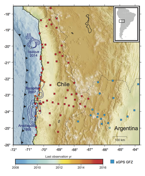
The survey-mode GPS (sGPS) network in the IPOC region consists of 91 geodetic markers (squares in Fig.1). Over the last decade, the positions of these points in the network have been periodically measured, thus enabling us to quantify the decadal patterns of deformation processes. This temporal catalogue of coordinates complement the continuous GPS (cGPS) array. Meta-data and raw data in Rinex format for the surveys carried out in 2008, 2011, 2013, 2014, 2015, and 2016 are available for 91 sites in the north of Chile and the northwest of Argentina. Included in this temporal catalogue are observations made shortly after the 2014 Pisagua-Iquique earthquake. Detailed information about data availability, metadata and site descriptions can be found here.
Our results indicate that the north Chilean seismic gap zone is currently in two distinct phases of the seismic cycle. The northern plate interface spanning the rupture zone of the 2014 Iquique-Pisagua earthquake (Mw=8.1) is still relaxing the stress perturbation caused by this event and is therefore in a postseismic phase, while the southern adjacent segment is undergoing compression and accumulation of slip deficit in the interseismic phase. The continued monitoring of the surface deformation in the seismic gap area will provide constraints for the temporal and spatial evolution of the plate interface kinematics and upper plate strain rates.
Partners and People
People involved: Marcos Moreno, Jonathan Bedford, Juna Carlos Baez, Jürgen Klotz, Felix Hoffmann, Zhigou Deng, Isabel Urrutia, Camilo Rojas, Mahesh Shrivastava
Partner institutions: GFZ Helmholtz Centre for Geosciences, Universidad de Chile, Universidad Católica del Norte
Selected Publications
Moreno, M.; Melnick, D.; Rosenau, M.; Bolte, J.; Klotz, J.; Echtler, H.; Baez, J.; Bataille, K.; Chen, J.; Bevis, M.; Hase, H.; Oncken, O. (2011): Heterogeneous plate locking in the South-Central Chile subduction zone: Building up the next great earthquake. Earth and Planetary Science Letters, 305, 3-4, 413-424, EDOC: 16965, doi.org/10.1016/j.epsl.2011.03.025