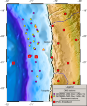
OBS Deployments offshore Iquique
Description
We plan to combine 24 months of continuous data from 14 ocean bottom stations (OBS) installed between December 2014 and November 2016 with the data from the permanent IPOC network and temporary landstations.
The integration of the offshore OBS data with the onshore seismology data provides a shore-line crossing data set with the exceptional capability to fully image the plate boundary in its entity. Previous data sets were only capable to capture the offshore domain up to the continental shelf or the onshore portion from the arc to the coastline. Here, we have the unique opportunity to bridge this gap. In particular, we want to investigate seismicity in the 2014 rupture area and the transition to the remaining seismic gap to the south of the Iquique earthquake, which last ruptured in 1877.
We plan to detect and locate the seismicity in order to obtain a high-resolution earthquake catalogue. This will allow resolving the spatial relation between postseismic activity and structural features such as variations in the topography of the plate interface, splay faults, internal structure of the seismogenic zone or transient fluid migration into the overriding plate, to establish a possible correlation between dehydration processes and the seismicity distribution in the upper plate. Then, local earthquake tomography will be applied to determine the 2D and 3D vp and vp/vs velocity structure and will contribute to a better understanding of lateral and downdip structural changes of the forearc.
Date: 2014/12 - 2016/11
Deployment Dezember 2014 - Dezember 2015
| Station | ID | Latitude | Longitude |
|---|---|---|---|
| OBS01 | N1 | -19.0992 | -70.9025 |
| OBS02 | N2 | -19.3498 | -71.3503 |
| OBS03 | N3 | -19.4998 | -70.9998 |
| OBS04 | N4 | -19.7502 | -71.1662 |
| OBS05 | N5 | -19.7498 | -70.7527 |
| OBS06 | C1 | -20.0095 | -70.8805 |
| OBS07 | C2 | -20.2502 | -71.0292 |
| OBS08 | C3 | -20.2493 | -70.7007 |
| OBS09 | C4 | -20.4993 | -70.8498 |
| OBS10 | S2 | -20.7518 | -70.9955 |
| OBS11 | S1 | -20.7487 | -70.7012 |
| OBS12 | S3 | -20.9992 | -70.8165 |
| OBS13 | X1 | -21.3502 | -70.9698 |
| OBS14 | X3 | -21.7498 | -70.8027 |
| OBS15 | X2 | -21.3348 | -70.6502 |
GEOMAR OBS Deployment RV Sonne SO244 (Dezember 2015 - Dezember 2016)
| OBS01 | -20.74152 | -71.06256 | -5350 | alkaline |
| OBS02 | -20.7685 | -70.79785 | -2501 | lithium |
| OBS03 | -20.46966 | -70.87623 | -2898 | lithium |
| OBS04 | -20.36685 | -71.06605 | -5071 | lithium |
| OBS05 | -20.1005 | -71.11888 | -4819 | lithium |
| OBS06 | -19.88998 | -71.2109 | -5346 | alkaline |
| OBS07 | -19.6023 | -71.2775 | -4887 | lithium |
| OBS08 | -19.34578 | -71.0216 | -1735 | alkaline |
| OBS09 | -19.5798 | -70.83018 | -1729 | lithium |
| OBS10 | -19.8154 | -70.72756 | -1432 | alkaline |
| OBS11 | -19.94056 | -70.93186 | -2736 | lithium |
| OBS12 | -20.2015 | -70.9003 | -2998 | lithium |
| OBS13 | -20.2953 | -70.73083 | -2100 | lithium |
| OBS14 | -21.54985 | -70.75005 | -2787 | lithium |
Partners and people
People involved: Dietrich Lange, Eduardo Contreras Reyes, Ingo Grevemeyer, Heidrun Kopp
Partner institutions: GEOMAR Helmholtz Centre for Ocean Research Kiel, GFZ Helmholtz Centre for Geosciences, Universidad de Chile
Data
the data are available upon request, please contact Dietrich Lange.
Selected Publications
tbd