Geodesy at the sea floor: Investigating plate boundary deformation offshore Chile
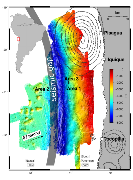
In 2015 during the Sonne cruise SO244, three autonomous geodetic arrays were installed to measure sea floor deformation on the northern Chilean margin. The motivation for sea floor geodetic measurements lies in the fact that our understanding of earthquake processes in the framework of classic elasticity theory is well developed, while the evolution of strain through the interseismic and co-seismic phases remains poorly understood. The ability of terrestrial geodetic networks to precisely measure crustal deformation with millimetre accuracy in the form of lateral movement and/or vertical displacement has enormously advanced our knowledge of fault slip and earthquake rupture propagation over the past decade. However, much of the elastic strain build-up and release associated with large subduction zone earthquakes occurs offshore. The satellite-based GPS technique upon which terrestrial geodesy is largely based is not applicable in oceanic areas due to the opacity of seawater to electromagnetic radiation. The vertical displacement of the sea floor is measured by monitoring pressure variations at the sea floor. Horizontal sea floor displacement can be measured either using an acoustic/GPS combination to provide absolute positioning or by long-term acoustic telemetry between different beacons fixed on the seafloor to determine relative distances by using the travel time observations to each other. The latter technique is used in the current GeoSEA array set-up. The three geodetic arrays are located in the outer rise, and on the lower and middle continental slope. The arrays monitor the inter-station distances parallel and across morphological features at the sea floor which have been identified in high resolution bathymetry and have been interpreted as surface expressions of faults at depth.
Study Site
Coordinates:
- Area 1: 70° 50.1' W – 70° 48.2' W 20° 48.3' S – 20° 47.1' S
-Area 2: 71° 44.4' W – 71° 43.5' W 21° 3.6' S – 21° 3' S
-Area 3: 71° 5.22' W – 71° 2.7' W 20° 48.3' S – 20° 46.1' S
Partners and People
People involved: Heidrun Kopp, Dietrich Lange. Katrin Hannemann, Florian Petersen
Partner institutions: GEOMAR Helmholtz Centre for Ocean Research Kiel
Selected Publications
Kopp, H., Lange, D., Hannemann, K., Krabbenhoeft, A., Petersen, F. und Timmermann, A., eds. and Scientific Crew SO244-II (2016) RV SONNE Fahrtbericht / Cruise Report SO244/2, GeoSEA: Geodetic Earthquake Observatory on the Seafloor, Antofagasta (Chile) – Antofagasta (Chile), 27.11.-13.12.2015. GEOMAR Report, N. Ser. 034 . GEOMAR Helmholtz Centre for Ocean Research, Kiel, 86 pp. doi.org/10.3289/GEOMAR_REP_NS_34_2016
Contact