
Lascar volcano
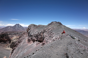
Láscar Volcano, located in the Chilean Andes 70 km SE of San Pedro de Atacama, is the most active volcano of the Central Volcanic Zone. Today the volcanic complex consists of the dormant western edifice and the active eastern edifice, the latter comprising three overlapping craters. The volcanic complex experienced several major, up to VEI 6, pre-historic eruptions but no calderas were formed. It was suggested the nested craters of Láscar did not form due to a large explosion nor due to simple collapse but rather as a result of long term cyclic activity: dome growth, followed by degassing of a shallow magma reservoir and conduit, resulting in subsidence of the dome and further deepening of the crater floor.
Country: Chile Volcano
Type: Stratovolcano
Status: Historical, recent phreatic explosions (2015)
Summit Elevation: 5592 m
Latitude: 23.37°S
Longitude: 67.73°W
Seismicity
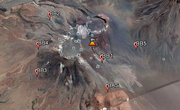
Continuous seismic monitoring at a single station was installed in 2011. The station was operating discontinuously until 2015. Data available through GEOFON. A seismic monitoring experiment was realized in 2008. Data available through GEOFON. See the station distribution here and the data availability here. Contact of lead scientist: T.R. Walter
| Station Code | Datalogger | Sensor | Sampling Rate | Lat | Long | elev. [m] | Start | End |
|---|---|---|---|---|---|---|---|---|
BB1 | DSS-CUBE A84 | Trillium compact | 100 sps | -23,37958 | -67,72790 | 5026 | 12.04.14 | 29/08/2014 |
BB2 | DSS-CUBE A7Y | Trillium compact | 100 sps | -23,34669 | -67,74794 | 4668 | 01.12.14 | 25/05/2015 |
BB3 | DSS-CUBE A89 | Trillium compact | 100 sps | -23,37330 | -67,76683 | 4422 | 08.04.14 | 23/08/2014 |
BB4 | DSS-CUBE A8C | Trillium compact | 100 sps | -23,37330 | -67,76683 | 4422 | 29.11.14 | 23/05/2015 |
BB5 | DSS-CUBE A82 | Trillium compact | 100 sps | -23,35994 | -67,76017 | 4604 | 08.04.14 | 24/08/2014 |
BB6 | DSS-CUBE A8B | Trillium compact | 100 sps | -23,37861 | -67,70632 | 4785 | 10.04.14 | 28/08/2014 |
Terrestrial laser scanner data
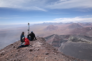
Light detection and ranging (LiDAR) is based on the measurement of the time delay between the emission of a laser pulse and the reception of the echos that return from target objects. This way, topographic details can be scanned over large areas with great precision and in relatively little time. At Lascar the LiDAR instrument was carried up and operated on the ground for terrestrial laser scanning (TLS). Data allows to study structural and geomorphological features at the nested craters of Láscar Volcano, Chile. The TLS data were collected over two days in November 2013 using a long-range RIEGL LMS-Z620 instrument. Data is available for free at doi.org/10.5880/GFZ.2.1.2016.002
Time lapse camera: Near continuous data stream since 2011
Fumarole temperature: Near continuous data stream since 2011
Deformation: Near continuous monitoring using TerraSAR since 2012
Topography: Drone based and lidar based data from 2014, 2015 and 2016
Infrared: FLIR data annual 2011-now
Meteorological station