Lastarria volcano
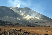
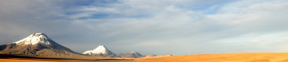
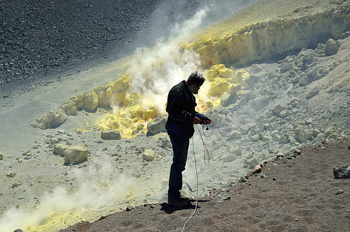
Lastarria volcano is a NNW-trending edifice located in the border region Chile-Argentina, just at the northern end of the larger Lazufre volcanic region. Lastarria volcano, 5700m altitude, had no historically documented eruption, but is an ideal test site for monitoring fumarole fields. The youngest feature is a lava dome that overlaps the northern crater rim (see image left side). The fumarole fields at Lastarria express temperatures exceeding 300°C, and are located on the gently deforming (inflating) volcano edifice. Monitoring comprises both continuous and discontinuous sites, complemented by experimental data.
Monitoring organization:
| site | lat | lon | elev. [m] | install date | continous | experimental |
|---|---|---|---|---|---|---|
| Lastarria | 25.17°S | 68.50°W | 5697 | 2008 | S, TLC, T, Met | Def, Topo, IR |
S-Seismic stations, TLC-Time lapse cameras, T-temperature and thermocouples, Met-Meteorological stations, Def-Deformation, Topo-Topography, IR-Infrared
Seismicity
Continuous seismic monitoring at a single station was installed in 2011. The station was operating discontinuously until 2015. Data available through GEOFON. A seismic monitoring experiment was realized in 2008. Data are also available through GEOFON (https://doi.org/10.14470/7T7561754109). See the station distribution here and the data availability here. Contact of lead scientist: T.R. Walter
Deformation
Deformation is monitored by satellite radar interferometry. We utilized ERS, ENVISAT and SENTINEL data. Closer observations at the summit crater are derived from the German satellite mission TerraSAR-X. Because of the high resolution needs, data are acquired and processed in SPOT mode, leading to a spatial resolution better than 2m. The satellite radar raw data is available from the German Space Agency (DLR) on request. Contact of lead scientists: T.R. Walter and N. Richter
Time lapse camera
Near continuous time lapse camera monitoring was realized in 2011. Aim of the camera monitoring is the assessment of the visual intensity of the fumarole sites. Fumarole intensities are then characterized by modern computer vision approaches, applying change detection, intensity variance and frequency dependent time series analysis. Because of the harsh environmental conditions, the cameras had to be replaced in 2012, 2014 and 2015, shortly associated with a gap in the time series. Data available on request, contact of lead scientists: T.R. Walter and J. Salzer
| Station Code | LAS_TLC1 |
| Place | Lastarria volcano |
| Country | Chile-Argentina |
| Datalogger | Mobotix |
| Sensor | Mobotix |
| Sampling Rate | 10 min |
| Latitude | -25.141175° |
| Longitude | -68.536934° |
| Altitude | 4598 m |
| Start date of the station | 11/2011 |
| End date of the station | running |
| Station Code | LAS_TLC1 |
| Place | Lastarria volcano |
| Country | Chile-Argentina |
| Datalogger | Nikon D5100 |
| Sensor | Harbortronix |
| Sampling Rate | 60 min |
| Latitude | -25.159057° |
| Longitude | -68.543606° |
| Altitude | 4675 m |
| Start date of the station | 1/2011 |
| End date of the station | 12/13 |
Fumarole temperature
| Station Code | LAS_T |
| Place | Lastarria volcano |
| Country | Chile-Argentina |
| Datalogger | Meier-NT |
| Sensor | Thermocouple |
| Sampling Rate | 1 min |
| Latitude | -25.154469° |
| Longitude | -68.525138° |
| Altitude | 4991 m |
| Start date of the station | 1/2011 |
| End date of the station | running |
Topography
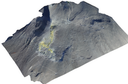
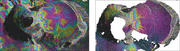
High resolution topographic datasets are the basis for many follow up studies, including structural geology, geomorphology, but are also needed for correct assessment and processing of InSAR data and others. The use of UAVs allows for the acquisition of high resolution imaging data, greatly improving the resolutions of geomorphologic and structural data obtained by other methods. In different experimental campaigns we used lightweight cameras mounted on multicopter drones and on helium filled balloon-kites to acquire digital terrain models at centimeter scale resolution. Photo images are photogrammetrically processed using the Structure from Motion (SfM) approach, able to reproduce high resolution 3-D surfaces from 2-D photographs. Data available on request, contact of lead scientists: T.R. Walter
| Station Code | LAS_SfM |
| Place | Lastarria volcano |
| Country | Chile-Argentina |
| Datalogger | Camera internal |
| Sensor | Camera |
| Sampling Rate | 0.5 Hz, 12 Mio px, over 20,000 images |
| Latitude | various |
| Longitude | various |
| Altitude | 5500 m |
| Start date of the station | 2014, 2015, 2016 |
| End date of the station | running |
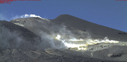
Infrared
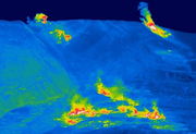
Apparent temperature measurements using forward looking infrared cameras. This measurement is done annually during each visit at Lastarria volcano. The FLIR camera, which operates in the 7.5–13 µm wave band, was calibrated to a temperature range of 0–500°C. The resolution of the FLIR camera used in this study was 640 × 480 pixels. We combined the camera with a 7° (f = 131) zoom lens with a 0.38 mrad instantaneous field of view.
| Station Code | LAS_IR |
| Place | Lastarria volcano |
| Country | Chile-Argentina |
| Datalogger | SD |
| Sensor | FLIR P660 |
| Sampling Rate | 640x480 |
| Latitude | various |
| Longitude | various |
| Altitude | 5500 m |
| Start date of the station | 2013, 2014, 4/2016, 11/2016 |
| End date of the station | running |
Meteorological Station
| Station Code | LAS_Met |
| Place | Lastarria volcano |
| Country | Chile-Argentina |
| Datalogger | Meier NT |
| Sensor | Vaisala WXT |
| Sampling Rate | 1 Hz |
| Latitude | -25.130068° |
| Longitude | -68.540008° |
| Altitude | 4467 m |
| Start date of the station | 2014 |
| End date of the station | running |