
Lazufre volcanic region
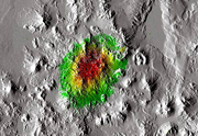
Lazufre is defining a region exceeding 1000 km² in size between the Cordon del Azufre and Lastarria volcanoes. Lazufre has been identified by satellite radar interferometry as one of the major inflating volcano systems on earth. Monitoring comprises seismicity and satellite based remote sensing. Scientifc results reveal that Lazufre is underlain by a magma intrusion that developed around 2007-8, located at around 10 km depth and elongated NNE-SSW. The elliptical deformation region at the surface is showing uplift rates up to ~3cm annually. Seismic studies showed that only weak seismicity is accompanying this inflation episode.
Monitoring organization:
| site | latitude | longitutde | elevataion [m] | installation date | continous | experimental |
|---|---|---|---|---|---|---|
| Lazufre | 25.33°S | 68.50°W | 5481 | 2007 | S, Def |
S-Seismic stations, Def-Deformation
Seismicity: A seismic monitoring experiment was realized in 2008. Data available through GEOFON (https://doi.org/10.14470/7T7561754109). See the station distribution here and the data availability here. Contact of lead scientist: T.R. Walter
Deformation: Deformation is monitored by satellite radar interferometry. We utilized ERS, ENVISAT and SENTINEL data. ENVISAT data was exploited in wideswath and image mode. The satellite radar raw data is available from the European Space Agency (ESA) at no cost, e.g. through the EO websites here. Contact of lead scientist: T.R. Walter