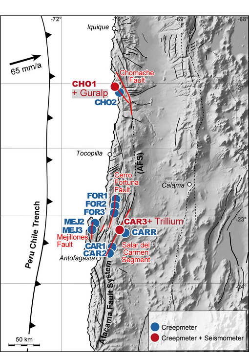
Creepmeter Overview
The following table is an overview over the sites:
| Location | depth | |||||||
| site | latitude | longitude | elev [m] | installation date | azimuth (°) | length [m] | head [cm] | end [cm] |
| MEJ2 | -23.11633° | -70.49550° | 139 | 2008/11/26 | 84 | 3 | 60 | 40 |
| MEJ3 | -23.13017° | -70.49981° | 170 | 2009/11/23 | 112 | 3 | 50 | 50 |
| CHO1 | -21.09405° | -70.10200° | 653 | 2008/12/04 | 90 | 6 (7) | 50 | 80 |
| 5 | 6 (7) | 50 | 80 | |||||
| CHO2 | -21.10593° | -70.09690° | 620 | 2008/12/06 | 84/10 | 2 | 40 | 20 |
| FOR1 | -22.84233° | -70.18320° | 1077 | 2009/04/06 | 75/05 | 5 | 90 | 90 |
| FOR2 | -22.86562° | -70.17733° | 1089 | 2009/04/08 | 124 | 4 | 80 | 80 |
| FOR3 | -22.87673° | -70.17912° | 1107 | 2009/11/24 | 78 | 9 | 50 | 50 |
| 140 | 9 | 50 | 50 | |||||
| CAR1 | -23.74003° | -70.31507° | 551 | 2009/04/09 | 120 | 9 | 50 | 70 |
| CAR2 | -23.74107° | -70.31516° | 570 | 2010/10/23 | 106 | 9 | 50 | 50 |
| CAR3 | -23.51146° | -70.24965° | 697 | 2011/11/15 | 120 | 9 | 60 | 40 |
| CARR | -23.51221° | -70.24395° | 666 | 2011/11/15 | 025 | 9 | 50 | 45 |
| 115 | 9 | 50 | 55 | |||||
Creepmeter Sites